New forensic aerial photographic method proving extremely valuable

Invaluable, is the best way to describe this forensic method.  Drones fitted with cameras taking low-level, aerial photographs and video at the scene of an engineering failure or personal injury accident.  It`s proving to be just that – invaluable, during a forensic engineering investigation.

I blogged on this method last year, January 15, 2014. (Ref. 1)  I’m even more enthused about the technique now.

Recent use

I’ve used this photographic method twice in the last few months to gather data and to document conditions at sites in eastern Canada.

I understand the RCMP are using drones fitted with cameras to photograph traffic accident sites.  I`m sure in other ways as well.  I can imagine they are as enthused as I am.

Typical low-level, oblique aerial photographs are shown in the Appendix.

Future plans

I’ll definitely take aerial photographs at the site of the next slip, trip, and fall accident that occurs outdoors that I investigate.  Also flooding and drainage problems, and fuel oil spills.

For that matter, I’ll take aerial photographs and video of the scene of any failure in the built or natural environment when the failure is comprised of some outdoor elements. Also photographs of features of interest on the upper levels of structures both outside and inside – where the structure is large and open inside and suitable for flying a drone.

Low level aerial photographs are a big step up – no pun intended, from forensic engineering terrestrial photographic practice in the past.

For example, old methods from past civil litigation cases….

I used binoculars not too long ago to examine the condition of the second and third levels of a building.  Ice had fallen from the building and seriously injured a pedestrian.  Boom trucks have also been used to facilitate this type of examination.  I`m sure people have repelled down the side of a structure from the roof or upper levels to do this.  I used a boom truck and a sea king helicopter during one forensic investigation to film the re-enactment of a fatal motor vehicle accident.

Aerial photographic and filming technique

Most of the photographs and video taken during my recent cases were oblique – tilted at an angle to the horizontal, but some were vertical.  Tilt is adjusted by the pilot during flight.  The photographs are taken with cameras mounted on a small drone – in this case a four rotor, quad-copter, flown remotely by the pilot on the ground at the site.  The drone is also fitted with an altimeter to record height.

There are six and eight rotor drones available. More rotors increases the control and stability of the drone and the on-board camera.  Heavier, higher quality cameras with increased resolution can be carried by drones with more rotors.

I direct the photographs and videos to take from a monitor mounted on a tripod near the pilot.  The directions include:

  • Specific view of the site wanted – front, back, side, etc.
  • Altitude above the site
  • Distance – close-up, mid range, distant
  • Tilt (oblique) angle, and
  • Photograph or video

In my cases, most photographs and video were taken at 45 to 55 metres, some were at a few metres, and one was close to 100 metres above the site.

The photographs and video are down loaded to a disc for use by the forensic engineer and client.  You get 100s of aerial photographs of a site using this technique.  It takes much more time to review, select, and study the photographs for evidence than it does to take them.

It took two to three hours to fly and photograph each of the sites I’ve investigated recently.

Experimenting with this method

I’m experimenting with this method – it’s new to forensic engineering, and I’m trying new things and I`m liking the results.  This time at one of my sites I took high – several 10s of metres, distant photographs from different angles to show the general setting – the context of my site and it’s problem.  Then I took close-ups at a height of a few metres showing the specific location of the problem I was investigating.

Also at one of my sites this time I marked the location of features of interest on the ground with sheets of white paper that would be visible from the air.  These important features would not stand out otherwise.  I also noticed important features on studying the aerial photographs of one site – unexpected, forensic engineering data, evidence, that would not have been seen on the ground.  This data will be quite valuable in my assessment of the problem at this site.

In future experiments, I will investigate increasing the accuracy of scaling distances from the photographs – a task of interest often enough, by setting horizontal control markers on the ground before photographing the site.

I also want to investigate distortion in low level, vertical photographs.  This distortion is seen in trees and vertical structures leaning away from the centre of an aerial photograph, which, of course, they don’t do in real life.  Finally, at present, maybe investigate measuring the contour of the ground surface with a stereo pair of low level aerial photographs.  Other experiments are certain to occur to me.

Another just occurred to me as I was checking this blog before publishing.

These low level aerial photographs will be good for terrain analysis and evaluation of the small compact sites typical of engineering failures and accidents.  Terrain analysis is a valuable technique in geotechnical and foundation engineering investigation for a preliminary assessment of the soil conditions beneath a site.

Easy and inexpensive

This photographic technique is easy and inexpensive – hundreds of dollars compared to thousands.

The drone pilot operates the equipment and flies the drone.  The forensic engineer directs the photography.  This is not too much different from an engineer knowing what terrestrial photographs to take during an initial visual examination of a site. (Ref. 2)

I can easily imagine that low level aerial photography will be standard fare in the future.  Like terrestrial photography during many initial visual assessments where an element in the forensic case is the terrain at the site of a failure or accident.

There is a bit of a learning curve for viewers of oblique aerial photographs because we are not use to seeing a site this way.  But a curve we quickly climb when we see the advantage of these photographs and the additional evidence that can be got from them.

Ensure your expert is familiar with this technique

It seems important for your next problem, engineering failure, or personal injury accident that you ensure your expert is familiar with this forensic engineering method.

References

1. http://www.ericjorden.com/blog/2014/01/15/a-pictures-worth-a-1000-words-possibly-many-1000s-in-forensic-engineering-with-a-new-aerial-photographic-technique/
2. http://www.ericjorden.com/blog/2012/09/04/technical-visual-site-assessments-valuable-low-cost-forensic-engineering-method/

Appendix: Oblique Aerial Photographs

The first aerial photograph was taken from an altitude of about 50 metres.  The second, close-up was taken from about 4 metres.  The two black, barely discernible dots in the first photograph to the right of the long white building and just across the gray driveway are me and the drone pilot, Robert Guertin, Dartmouth.

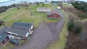
Sample aerial photograph of a site in eastern Canada with a forensic engineering problem.


Experts benefit from reading legal practice handbooks

Headaches caused by obscure, poorly defined fields of practice

Recently, I was researching practice for the forensic investigation of a personal injury accident, and standards for evaluation of the results. The practice and standards were not so well defined and somewhat silent, respectively, – obscure investigative practice and not well established standards in eastern Canada, better in the U.S., in both respects, and better still in Europe.

Research a year and a half ago of industrial practices, as distinct from investigative practices, of a similar accident identified 11 different potential parties involved in design and construction of the component of the structure responsible for the accident.

These kinds of situations cause forensic engineers and experts – and counsel by extension, lots of headaches.

My recent research was identifying engineering literature and bringing it in by inter-library loan for review.  Engineers know a lot but we must sometimes research a lot – poorly defined fields of practice for sure.

Striking gold in an “engineering” handbook

One “engineering” handbook – the title wasn’t clear – turned out to be a legal practice handbook on this particular type of accident.  What the heck, I thought, I’ll look through it. Imagine my surprise when I saw the handbook identifying and discussing the technical issues in these types of accidents.  The discussion was from a legal point of view but the perspective was very informative to an engineer.

The legal handbook was dated – 1983 to be exact, but at least I had a heads-up on a different way to view these technical issues.  And a better feel on how to explain the investigative findings on these issues to the judicial system and counsel.

More gold

I checked a quite extensive bibliography in a very comprehensive, 2nd edition, 2010 engineering handbook that I’m reviewing on this type of accident.  I was delighted to see a well recommended reference – by an engineer, to a more recent legal handbook on the subject – by an author qualified as both a lawyer and an engineer.  I checked and the handbook was available, and better still, in a revised and updated 8.5 by 11 inch, 613 page edition, to July, 2012 – quite an up-to-date tome.

I’m now reviewing this legal material in connection with my cases.  Even the 1983 handbook because the engineer in me saw not so much change in the basic relevant technical issues. This type of accident is still a somewhat obscure field of study and, as a result, a difficult accident to investigate, but at least I’ve got comprehensive and up-to-date literature on another way of looking at the problem.

What’s the take-away?

So, what’s the take-away?  For forensic experts, and counsel too, check out the legal practice handbooks on the engineering failure or personal injury accident you’re investigating, particularly handbooks on poorly defined fields.  Look at the perspective the legal profession has on the technical issues.  To some extent, you’ll know the obscure fields by the dearth of information on practice and standards.

Counsel too

I include “counsel too” because – with all due respect, I sense in my work that some of you have so many files open – I’ve heard “dozens”, “hundreds”, depending on the lawyer I was chatting with, that it surely precludes taking the time to check the handbooks for the relevant technical issues in a case.

If your expert doesn`t know about this excellent resource – your legal practice handbooks, like I didn’t until recently, tell him and bring him up to speed.  He’ll benefit and you will too by his more informed investigation..

A bonus in checking your legal handbooks – you’ll gain some appreciation, and not be surprised, at the lengthy forensic investigation an expert must sometimes do, particularly in the obscure, poorly defined fields of practice.

Forensic engineers learn from sometimes boring success as well as newsworthy failure

We learn when things fall down or don’t work as they should.  We learn from mistakes – our own as well as those of others.  I see these lessons in the engineering failures and personal injury accidents that I investigate.

There is an element of judgement in the practice of engineering.  Particularly those engineering disciplines based on the semi-empirical sciences.  Disciplines like geotechnical, foundation, earthworks, environmental, and hydraulic engineering.  Good judgement comes from lessons learned.

We also learn when things stand up – when we get it right, particularly from structures that are still functioning after many years.  Things that stand up and work for a very long time.

I thought of this when I learned about the government’s plans to try and sell the Porter’s Lake Canal to developers who would fill it in and build houses on it.  Heaven forbid.  The Canal is functioning today almost as intended by engineers and builders when planning first began more than 135 years ago.  (Fortunately, the Canal has since been taken off the market by Fisheries and Oceans Canada as a result of public feedback)

The Canal is a hydraulic structure.  It connects 18 mile long Porter’s Lake in Nova Scotia to Three Fathom Harbour on the eastern shore.  You cross it when you travel highway 207 between the communities of Seaforth and Three Fathom Harbour.  It forms an unofficial boundary between the communities.

Porter’s Lake Canal is a little more than 0.5 miles long and was designed to be six feet deep at mean low tide.

It’s also pretty enough when you paddle or hike it’s length.  It looks like a hockey stick from the air.  Can you get any more Canadian, more Nova Scotian than that?

The Canal’s straight alignment stands out as an unusual feature in the landscape from several thousand feet aloft – go see, obtain a published aerial photograph of the area taken from 6,000 feet (at the Geomatic’s Centre in Amherst).  I’m sure it would stand out on the moon with a good telescope.

It was planned, designed and constructed by the community, engineers and builders in the late 1800s. The Provincial Engineer reported on the feasibility of the Canal in 1878.  It was intended to provide better and more reliable access to the sea from Porter’s Lake for quite small coastal schooners – and markets for the natural products along the shores of the lake at the time.  Rocky Run, the natural access to the sea from the lake, kept filling up with gravel from the action of the surf and the heavy seas of the Atlantic Ocean.  It was dredged several times.

The Canal hasn’t filled up in all those years, a main requirement the engineers had to meet.  Engineering judgement would have been important in selecting Three Fathom Harbour as the location of the discharge end of the Canal, also in designing the slope of the Canal sides and the depth.  Scour and erosion, long shore drift, and slope stability are quite empirical engineering studies even today.

The lesson learned is that engineering judgement and somewhat un-glamorous empirical knowledge are valuable elements in designing and building structures that can last a long time.  A very long time – witness the still functioning Roman, multi-level, bridge-like aqueducts.

Like the Shubenacadie Canal in Nova Scotia of similar vintage, the Porter’s Lake Canal wasn’t used to the extent intended for similar reasons – new technology overtook both of them.  A bridge constructed over the Canal shortly before 1915 to carry the railway to Upper Musquodoboit was too low for even small coastal schooners to pass under.  Porter’s Lake Canal as a commercial venture was doomed at that time.

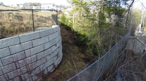
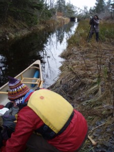
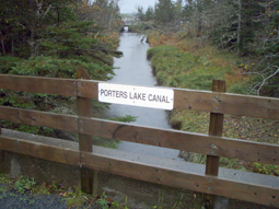
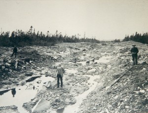
There are photographs of the Canal In Appendix 1 and additional, quite interesting historical information in Appendix 2.

The first photograph is of a paddler preparing to canoe the Canal.  CBC TV did a feature story on the public’s efforts to save the Canal.  The photographer in the middle distance is likely with CBC TV.

The second photograph is a view of the Canal from the Canada Trail where it crosses the Canal.  Hwy 207 is in the distance.

The third, rare photograph is of the Canal under construction.

Citations

Much of the information on the Porter’s Lake Canal including the photographs has been provided by Dusan Soudek, Halifax, an avid outdoors-man, who, I think, has a day job in medicine.  It was Dusan, possibly assisted by others, who located the following published items from the The British Colonist 1871.  My initial thoughts on the Canal on reading some of Dusan’s material is also included below.  It’s all quite informative reading on a very interesting engineering structure right under our noses – a short distance outside of Dartmouth.

Appendix 1

OLYMPUS DIGITAL CAMERA


OLYMPUS DIGITAL CAMERA


Figure 3

Appendix 2

The Porter’s Lake Canal

The value of this great improvement is not generally understood. It may be briefly, summed up as follows. Porter’s Lake is about eighteen miles in length, and surrounded by farms and woodland, and there are large quantities of building-stone and sand, all of which would prove valuable sources of wealth, if vessels of moderate tonnage could have free access to the ocean. But, unfortunately, the natural outlet from the lake is directly from the open sea-board, and, from the action of the surf, is being constantly filled up with gravel, although it has been dredged out several times. By cutting a canal from the lower part of the lake to Three Fathom Harbor, an outlet would be obtained which would never be liable to be choked up, as the harbor is sheltered from the heavy seas of the Atlantic.

The distance from the lake to Three Fathom Harbor is a little over half a mile, and from the nature of the soil could be cut of the depth of seven feet, which is as deep as is necessary, for an estimated sum of two thousand pounds. Were this accomplished, the whole of the great resources of the surrounding district would be developed, and the value of all the properties enhanced. For many years the residents have been hoping to obtain this important boon, but without success. We are happy to know, however, that at length they are in a fair way to secure it.

The residents of the district signed a petition to the Dominion Government asking for aid towards the work, which the Government have promptly responded to by sending an engineer to make a survey and make a report on its practicability and probable cost. There can be no doubt of the nature of the report on both points. Mr. Fairbanks has already, at the request of the inhabitants, made a preliminary examination, and his report proves not only the entire practicability of the work, but the very moderate amount necessary to effect it – not probably exceeding 2 000 pounds. Should the Government Engineer’s report corroborate Mr. Fairbanks’s (of which there can be no doubt) the work will be undertaken and completed by the Dominion Government, and a great and lasting boon thus conferred on the people residing in that part of the county.

(unsigned editorial, The British Colonist (Halifax), May 6, 1871)

Porter’s Lake Canal

This important public work is now demonstrated to be practicable. It can be constructed, and must be. The persons who sneer at the enterprise and regard it as an electioneering dodge would of course kill it off if they could. The matter is in the hands of the people.

(unsigned editorial, The British Colonist (Halifax), May 6, 1871)

That Canal

The Government Candidates with “Hon. William Garvie” at their lead continue to sneer at the Porter’s Lake Canal. They call it a “canard,” a “dodge,” an “invention,” a “piece of deception,” a “walking falsehood.” What more names they may have for it we do not know; but we know that the project is a wise one, perfectly practicable, quite within reach as to the means for its construction. We know further that the people most deeply interested in it, the inhabitants of the district, do not regard it as a “walking falsehood.” What do they or we care for second hand Theodore Hook stories? We are grappling with practical realities. We all know that the Canal will not be encouraged by the Local Government or its nominees. We do not wonder then that the people around Porter’s Lake are determined to support Messrs. Hill, Daly, and Geddes.

 (unsigned editorial, The British Colonist (Halifax), May 9, 1871)

Eric,

thanks for your intriguing thoughts about the canal. I am sending you, separately, a rare photo of the canl while it was being excavated and my notes about its history. It is shaped like a hockey stick… Can you get more Canadian than that?

In late 19th century the Dominion government was plagued by storms silting up Rocky Run, the natural outlet of the lake, trapping schooners in the lake for weeks. At one point the feds were working on three separate outlets for the big tidal lake. The site chosen for the current canal was superb; it hasn’t silted up for a century and likely never will… Regards,

Dusan 4/11/14

You know, Dusan, the Canal is a quite striking engineering structure.  Straight and true, covering a lot of ground, built by men long ago with far less sophisticated earth moving, mechanical equipment than available today.

Not such a complex structure in engineering terms but still an old structure built by man.  Not in the same league as the Shubie Canal but respectable enough, if for no other reason but that it’s about 100 years old, just a little less than Shubie.

And it’s being used today.  How many 100 year old engineering structures are being used today in Nova Scotia, other than a very few buildings, a very few wharves, and a few winding, twisting roads?

We have two main environments that figure in the affairs of man, a natural environment and a built environment.  This is a good example of a different structure in the built environment – something other than buildings, that represents the efforts of men.

And don’t forget, mankind has the built environment and all the comforts associated with it – I know, some problems too, because of the engineering profession, and the forebears of engineering centuries ago, builders in general.

And it’s an interesting structure that got built by our forebears.  Unlike the planned canal across the Tantramar Marshes that didn’t go anywhere because it didn’t get built.  But like the Shubie Canal that did get built.

But, unlike the Shubie Canal in that, to some extent, it’s being used today to something akin to its intended purpose long ago.

And it’s so striking from the air – in the aerial photograph, like an arrow shot across the landscape.  A feature like that draws the attention of those of us aloft.

You know, a structure like this – the Porter’s Lake Canal, just might show up on a photograph taken from the moon or Mars.  And it would draw the attention of Martians because it is an unnatural feature.  Bet your boots, someone is up there looking down on us.

More seriously, but only a little, this structure does show up from some distance off in space; there’s no question about that.  In view of that, I think, rather than abandon the Canal to real estate developers and someone’s bottom line, we should clear the forest growth back a little, just a little, so it is more visible from the air, be more inviting to paddlers, and be another feature that marks Nova Scotia as different from the rest of the east coast.

Dusan, feel free to share my e-mail thoughts with others with the view that it might stimulate additional thoughts of theirs, sorta like in a brain storming session.

Okay, take care…Eric 4/11/14

Eric,

think much smaller coastal schooners, not the Bluenose. it may have been meant for logs, too. There is a mention in the old documents that it was to be 6 feet deep at mean low tide.

I forgot to mention the name of the trail on the former rail right-of-way: The Atlantic View Trail, now a portion of the Trans Canada Trail. Regards,

Dusan 17/11/14

Hi Eric,

the road that crosses the canal is Highway 207, and the canal forms the unofficial boundary between the communities of Seaforth and Three Fathom Harbour.

In my initial appeal I made a slight error. The concrete railway bridge that spans the canal has the date 1928 imprinted in it, so I assumed that the Musquodoboit Railway reached the canal in this year. In fact the line, between Dartmouth and Uppper Musquodoboit, was officially opened on July 1, 1915. The original railway bridge over the canal was a wooden trestle, to be replaced  by the current concrete bridge later.

So no schooners could pass under the low railway bridge as early as 1915, and the canal was doomed as a commercial venture then.  An 1878 report by the Provincial Engineer on the feasibility of a canal mentions the need for a “pair of small lock gates.” Regards,

Dusan 16/11/14

I have some great news to report. In response to public feedback, Fisheries and Oceans Canada has taken the canal property off the market, giving interested parties some breathing room to make plans for the canal’s future. It was discussed at this week’s HRM’s Harbour East – Marine Drive ( i.e., “Dartmouth”) Community Council meeting and is on the agenda for Tuesday night’s (November 18) HRM Regional Council meeting. (Agenda Item 11.3.5).

If you haven’t sent a note to the HRM Councillors re your support for keeping the Porters Lake Canal in public ownership and if you are inclined to do so, please consider sending a brief note to District 2 Councillor David Hendsbee at hendsbd@halifax.ca and to the entire Council at clerks@halifax.ca before noon on Tuesday.

Dusan Soudek 16/11/14

N.B. The sign on the former railway bridge that crosses the canal – see attached photo– disappeared sometime after Hurricane Juan..

Hi Lyse,

excellent! Kevin Murphy, the local Liberal MLA is also the Speaker of the House. He is getting forwarded messages of support for the canal from Councillor Hendsbee, who is also forwarding them to all the other HRM councillors and various provincial politicians. I am getting some of them, too. And, boy, there have been lots of them. The word is spreading… It never hurts to cc as many politicians as possible. There are plans to set up a “Save Porters Lake Canal” Facebook group in order to keep people abreast of developments and to have a place to post historical press clippings, photos, videos, etc.. Regards,   Dusan Soudek 5/11/14